

Island Peak, also known as Imja Tse in Nepal, is a popular choice for novice climbers who want to start their mountaineering adventure by summiting Island Peak and then moving on to other peaks.
We call it the "Island Peak" because of its stunning location in the center of the Chhukung valley. That looks like an island in an ice sea. Island Peak has an impressive, highly glaciated west face that climbs from the Lhotse Glacier; yet, the beautiful views from the top are a suitable reward for your efforts.
Several skills in safe mountain travel at high altitudes, such as glacier travel, scrambling, and moving on mixed snow and ice terrain, are taught and practiced throughout the trip. This trip requires good alpine abilities, and if you can't master them before joining us, you'll have plenty of time to study and practice them before reaching Island Peak. On the summit day on Island Peak, we will use a climbing rope to cross the crevassed glacier. Also, we will navigate ladders over them, ascend a fixed-line, and descend.
Program ( 31 Days )
A representative from Creative Adventure Nepal will meet you at the Tribhuwan International Airport (TIA) in Kathmandu and transport you to your accommodation. There will be a welcome supper in the evening when we can sample authentic Nepali food. In Kathmandu, spend the night.
You can use this day to explore Kathmandu or rest and prepare for your expedition. If you are interested in roaming the streets of Kathmandu, then we can set up a city tour guide for you.
On this day, you will meet with our guide and help you prepare for the Island Peak expedition. You can also shop around for essentials and other tools you might need for the journey. Also, we have to visit the Ministry of Tourism for our Island Peak expedition briefing.
Following breakfast, we board an early morning flight to Lukla. We arrive at Tenzing-Hillary Airport in Lukla after flying above the stunning green and white mountains. It is one of the world's most picturesque flying routes, culminating in a landing on a hillside surrounded by towering mountains. Also, we meet the rest of our crew members when we get to Lukla.
Following that, we continue our journey to Phakding through the wealthy settlement of Lukla. We just have a short hike today to help with acclimatization. If you want to do anything else, we can take a side journey to a local monastery. Overnight stay at a camp or lodge.
We will trek through lovely pine trees before continuing down the Dudh Koshi River to Namche Bazaar. After nearly an hour of trekking, we come across the gleaming Mt. Thamserku (6,608m) on our right and the alluring beauty of pine, fir, and juniper woods. Moreover, we even catch a peek of Mt. Everest, looking over the Lhotse-Nuptse range if the weather is clear.
Our trek continues until we reach Namche Bazaar's entrance, the gateway to Mt. Everest and the region's primary trade center. On this day, we will cross five suspension bridges, the tallest known as the Hillary Bridge. The hike from Hillary Bridge to Namche is steep.
Today is an acclimatization day. We can go to Namche's charming villages and get to know the Sherpas and their rich culture. Or, we can trek up to the Everest Glimpse Hotel and get a close-up view of Mount Everest. Trekkers may also visit the local museum, which contains exhibits displaying the area's native flora and fauna and the history of the Mount Everest region, while in Namche village or on their way back from the hike to the hike Everest View Hotel.
After breakfast, we set off for Tengboche. Namche to Phunki is a short walk. We travel from Phunki to Tengboche, a town home to the world-famous Tengboche monastery, the largest monastery in the Everest area. It is the largest monastery in the Khumbu area and is in the Sagarmatha National Park. You can see a panoramic 360-degree view of the Himalayas, including Mt. Everest, Nuptse, Lhotse, Ama Dablam, and Thamserku.
The monastery at Tengboche is ideal for experiencing the stunning Himalayan environment, with the Himalayas as a backdrop. We go to the monastery and photograph the breathtaking scenery in the morning. Then we continue our journey on an easy road through lush forests of birch, conifers, and rhododendrons.
This scenic path then descends to Debuche, crossing the Imja River before ascending to Pangboche (We can either walk on the upper or lower Pangboche trails). We will most likely take the upper Pangboche routes since they provide a more pure perspective of the Himalayas. In addition, we go to the Pangboche monastery. The walking becomes more moderate as we approach the Imja Valley. When we reach the Lobuche River confluence, the valley gradually opens. We enter the river and begin the ascent to Dingboche.
The route leading to Island Peak Base Camp is pretty steep. We rise south first, then east to the valley's main line. Then we take a twisting trail from the Lhotse Glacier below the southern slope of the moraine. We then continue walking along a nice streamside route. The Amphu Lapcha is in the southeast. A crisscross path goes to a broad valley surrounding the SW side of Island Peak via the Imja and Lhotse glacier moraines.
We start our trek towards the Island Peak High Camp from the base camp at 5600m. The trail begins off sandy, then transitions to grass before becoming boulder-strewn. Also, the route ascends many hundred meters beyond the base camp before cutting off the steep mountainside.
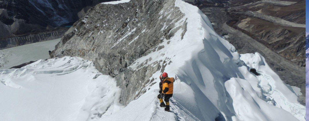
As we progress up the hill, the slope narrows, and the track becomes a steep rock channel. We scale the rock creek. It isn't tough, although there are a few small rock steps to climb before reaching the right side of the trench. The path traverses a ridgeline, leading to a thrilling and exposed trek onto the top glacier's snout. When a rope is needed, the guides will fix it. We reach the top ridge through a steep snow slope. We will utilize both fixed and man ropes during the climb for safety. After successfully ascending the rock, we used a fixed rope.
There are two new crevasses, measuring around 3 and 4 meters. We'll descend to Island Peak Base Camp, where some of our staff await us after enjoying the summit views and snapping photos. We celebrate our ascent of Island Peak and move toward Chukkung.
Today's hike to Chhukung begins with a stroll through stone-walled pastures and the Imja Khola valley, followed by a walk across glacier moraines. From here, we will continue our journey towards Dingboche. After resting in Dingboche for a while, we begin our trek towards the Ama Dablam base camp. As you get closer to base camp, the path will start to gain elevation at a more consistent rate. As you progress up the route and have a better view of the entire mountain, Ama Dablam will become more and more apparent.
To enhance our acclimatization, we will rotate among higher campgrounds. Before making the last summit attempt, it's good to turn to higher camps. As a result, we will climb to higher camps and then descend to lower camps to acclimate our bodies to the high altitude.
On the first rotation, we'll carry a modest weight to Camp One (5,600m/18,368ft), then return to Base Camp. On our next cycle, we will sleep at Camp One and ascend to Camp Two (5,900m/19,352ft) early the following day before descending. Those that are comfortable will sleep at Camp Two in the last rotation, while others will drop to lower camps to rest before making the final summit attempt.
Before reaching the summit, we'll put up three camps after Base Camp. Camp One is located at 5,600 meters (18,368 feet), Camp Two at 5,900 meters (19,352 feet), and Camp Three at 6,300 meters (20,664 feet).
We'll relax for a few days in the base camp until we're entirely acclimatized and wait for the optimal weather window to come for our last summit push.
Summit Day's most challenging hurdles are the snowy environment and altitude. The snow and ice track leads to Ama Dablam's east side. You'll also avoid the hanging glacier until reaching a tiny snowfield. Ice fields lead to a severely exposed location, where a 40–60 degree snow rib and the spectacular summit await. Everest, Nuptse, Baruntse, Pumori, Lhotse Shar, Makalu, and Cho Oyu are all visible from here.
Today's hike will be considerably more straightforward as we drop to lower heights. We take the same path back down the Khumbu Khola valley, passing past the lovely Sherpa settlements of Orsho and Shomare. We proceed through the rhododendron and juniper-covered mountainside.
Our path follows the Dudh Koshi canyon, dropping quickly through the pine trees until reaching Sansa, after passing the Dudh Koshi River bridge. While traveling through the forest, we keep an eye out for animals such as mountain goats, snow leopards, and colorful pheasants. We arrive at Namche Bazaar's army camp after going through a chorten.
The journey from Namche to Phakding is still ongoing. Take in the soul-calming vistas and fresh air throughout your rest intervals.
Because the route dips sharply, we must go with caution as our weak legs battle the rough terrain. After passing the suspension bridges across the fast-flowing Dudh Koshi and its tributaries, the trail becomes more level and natural. After arriving in Lukla, we stretch our tired legs and reminisce over the previous several weeks.
After our successful Island Peak expedition, we board an early morning flight from Lukla to Kathmandu. You can either rest or do souvenir shopping after we get to Kathmandu.
If you want to, you can explore other sections of Kathmandu today. Our tour guides can help you with both souvenir shopping and sightseeing. Also, we will host a farewell feast in the evening to mark the climbers' successful summit of the Island peak.
Today marks the end of your adventure. A Creative Adventure Nepal employee will bring you to the airport around 3 hours before your scheduled flight. You'll have plenty of time on the way back to plan your future adventure in Nepal's gorgeous country.